Course planning is arguably the most rewarding and enjoyable of all the volunteer roles you can do as an Orienteer. Not only does it improve your navigation skills, but it gets you out into the bush and it has the most impact on everyones enjoyment (and challenge) at an event. It is best to do your first course planning for a low key event and you need an experienced controller/vetter help you out.
Before you start
- Make sure you have 6 -8 weeks until the actual event. Course planning takes time and you’ll have to check with the OACT Office for any special conditions on approvals for the event location, do field checking, as well as wait for feedback from your controller/vetter. If you don’t know who your controller/vetter is, or if there isn’t a controller assigned to your event, you need to talk to your club event co-ordinator so they can find one for you. Course planning for major events can take considerably longer.
- Course setters are not expected to know the ins and outs of seeking permissions, but they should check with the OACT Office very early in the process to find out any special conditions that may be imposed that affect the course planning, assembly area, or require warnings to be issued to competitors. The time taken and information required for approval varies depending on the approval authority. Examples of approval authorities are: Private Landowners, ACT Parks & Conservation Service, National Capital Authority, local NSW Councils, traditional land owners, University and School campus, Military establishments, CSIRO etc. If the event is in Canberra Nature Park, urban parks or pine forests, all of which are managed by ACT Government Transport Canberra and City Services, or in Stromlo Forest Park, or land managed by the National Capital Authority, the OACT Office arranges approvals. If the event is held on private land or a campus, such as ANU, CIT, or a school campus, then the event organiser or course planner arrange permissions with the land manager. Note that many weeks’ or months’ notice may be necessary.
- Confirm the number and types of courses to be planned depending on the type of event.
- Contact your event organiser to coordinate the assembly location, parking and any other requirements for the event.
- Obtain the electronic version of the map to use for the event.
- Download and install course planning software.
Course Types
These are the courses you need to create. Don’t forget about Very Easy & Easy too – these courses can be challenging to plan. They need to be set according to the difficulty required and you should also be conservative with the number of controls you need to put out. For example, a termite mound near a track is suitable for an Easy course, and good for a Moderate course if the approach is perpendicular to the track.
Twilight and Metro Series
Very Easy
Easy
Moderate 1 & Moderate 2
Midweek Series
Easy
only in school holidays or if requested
Moderate 1 & Moderate 2
Classic Series
Very Easy
Easy
Moderate 1 & Moderate 2
Hard 1 – 4 or 5
Difficulty and Winning Times
The Twilight, Saturday Metro and Winter Midweek series are predominantly Middle Distance events, however then can have long route-choice legs if the terrain is suitable. There are usually about 3 or 4 events in the Twilight and Saturday Metro series which are Sprint or Short Course events. The type of event will generally depend on which map is being used. If it’s a school, like Radford College or Canberra Grammar School, then it will be a sprint event. Often the scale is a good indicator; a 1:5000 or 1:4000 map will likely be a sprint (but not always!) Also, some parks in ACT are suitable for sprint course, such as Fadden Pines, Weston Park and Commonwealth Park. It’s also fine to offer longer sprints (distance similar to middle distance), but you’ll probably have to use a lot of controls.
The classic program courses are Long Distance events. The guidelines for these are covered in depth in the OA Operational Manual (rule 16.9) and ACT Event Format Guidelines (and are not covered in detail in this document).
The course planner should be planning courses of a suitable length to achieve a winning time of 30-35 minutes for middle distance, and 15-20 minutes for sprint events. For example, if the terrain is steep and slow, then shorter courses should be planned, whereas fast easy terrain requires longer courses.
Definition: “winning time” means the fastest mens elite runner on the course.
Particularly in the Classic Program, it is good to offer a Hard course that is physically suitable for older competitors. If this is done, there could be a Hard 5 course offered that still provides the navigational challenge but is not so physically demanding in both distance and terrain, for example avoiding difficult terrain such as steep slopes, rocky ground, gullies, fence crossings and fallen timber.
Middle Distance Events
VERY EASY
Very Easy Navigation
1.5km – 2km
Controls only on line features
No route choices
Text and symbol control descriptions
For children and beginners
EASY
Easy Navigation
2.5km – 3.0km
Legs along line features
Controls should be visible from a line feature
Easy route choices allowed
Text and symbol control descriptions
For children and beginners
MODERATE
Moderate Navigation
Moderate 1: 5 – 5.5km
Moderate 2: 3 – 3.5km
Winning time 30min
Controls close to a line feature
Catching feature behind control
Symbol control descriptions
For most suburban Canberra maps these courses will be as difficult as possible
HARD
Hard Navigation
From 3km to 15km
Winning time 30min
Controls often on point features
Route choice & fine navigation
Symbol control descriptions
As challenging as possible (but controls must be fair)
Sprint Events
VERY EASY
Very Easy Navigation
1.0km – 1.5km
Controls only on line features
(on park maps)
No route choices
Text and symbol control descriptions
For children and beginners
EASY
Easy Navigation
2.5km – 3.0km
Legs along line features
Controls should be visible from a line feature
Easy route choices allowed
Text and symbol control descriptions
For children and beginners
MODERATE
Moderate Navigation
Moderate 1: 3.5 – 4km
Moderate 2: 2.5 – 3.5km
Winning time 15min
Use many changes of direction
May use a map change
Lots of route choice requiring quick decision making
Lots of short legs
Symbol control descriptions
As difficult as possible (but fair!)
The Map - Using Google Drive
Contact the office or the Mapping Officer for access to the OACT Mapping Library. A Google Drive folder will be shared with you. That folder will contain the map for the event you are course planning for as well as any other relevant files (parking plan, permission forms, etc). You should save your courses in this folder so they will be synced with the office computer (also a backup of your work). Once your courses are ready, the PDF files will be stored in this folder too. You can store any other relevant files (eg. course planner notes)
The map file is in OCAD (file extension .ocd) or Open Orienteering Mapper (.omap) format.
Note: Google Drive is an online file sharing system from Google. It is similar to Dropbox. You can install an application on your computer to automatically sync files, or you can use a web interface to manually download and upload files. If you are doing lots of course setting, it’s definitely recommended that you install the application as it makes your life much easier as all the syncing is completely automatic!
Course Planning Software
The recommended software to use for course planning is Purple Pen (free). It runs on Windows, however you can use it on a Mac with Virtual Box, Parallels, VMWare Fusion or Bootcamp.
Purple Pen Instructions (PDF file with screenshots)
Other course planning software includes OCAD CS (commercial) and Condes (free). OACT have laptops that can be borrowed from the office with OCAD CS installed.
Plan the courses!
Now you’re ready to start planning the courses! Here’s some tips to get you started:
- Figure out where the start should be. You should already know where the assembly area is. It’s fine for the participants to walk to the start. Be conscious of the Very Easy course requirements – they need to be on line features the whole way, including from the start to #1.
- Where is the finish? It’s great when the finish is very close to the assembly area.
- Have fun experimenting with the courses. Don’t be afraid to scrap everything and start again. Remember you’re planning courses for people to be challenged and to enjoy.
DO
✓ Plan a course that YOU would enjoy
✓ Consider fairness – if luck is going to play a role then change your control site
✓ Simple controls are ALWAYS better than unfair (or misplaced) ones
✓ Use controls to adjust the difficulty – many short legs with lots of direction changes can make a technically easy area difficult, while long legs can make a technically difficult area easy
✓ Use variety – mixing up the leg lengths, changes of direction and changes of speed/difficulty can make a course more enjoyable (don’t forget to look at courses from previous years so you can reduce repetition)
✓ Consider that terrain influences speed, and the slower the speed the easier the orienteering (with exceptions such as areas of low-visibility)
✓ Try to avoid “dog legs” but not at the expense of a good, challenging course (note this does not apply for sprint races where dog legs are often used for creating route choice options)
✓ Consider making the shortest Moderate course physically easier to match ability of competitors
✓ Ask for help
DON'T
✗ Obscure details with your course (lines, numbers, circles)
✗ Use a control site if you are not 100% confident you can put the flag in the correct spot – if in doubt change it or leave it out
✗ Place controls too close together (the rule is 30m for 1:10000 and 15m for 1:5000 maps) – if in doubt use a single control for multiple courses (don’t be afraid to use a lower difficulty control eg. use an Easy control on a Moderate course)
✗ Place controls in areas where the map is wrong
✗ Create route choice legs without checking the most likely routes on foot (for map changes, transient obstacles like flooded creeks or construction etc)
✗ Hide control flags
✗ Set a long “route choice leg” if there is no route choice
✗ Plan a long leg simply for the sake of having a long leg – difficulty is not a function of length, and long legs don’t always have route choice
✗ Have courses running a significant number of legs in opposite directions
✗ Set a route choice leg where the options are simply to pick “left” or “right” followed by dead running (this may be unavoidable in sprint)
✗ Be afraid to ask for help
Field Checking
This is a crucial step and must not be skipped. You need to visit the area and check all your control sites. There WILL be sites you need to change. You might have to change a site because the feature no longer exists (eg. termite mound gone or too small), a nearby feature is not quite right (maybe thick vegetation close by is now much bigger than the map shows), the area is poorly mapped, and many other reasons.
At every control site, always cross-check any surrounding features to ensure you are at the correct location, and also to check the accuracy of the map.
If possible, try to approach the controls in the same direction as the competitors. This gives you a much better idea of what the competitors will encounter and will identify any problems with the map from the approach side of each control site.
If there are multiple distinct route choices on a leg it’s important to check each leg to make sure that there aren’t any unfair situations that would make runners on one leg have an unfair advantage or disadvantage. For example, one leg might have thick vegetation that’s not shown on the map, or new construction not mapped, etc.
If you plan to use linear features as control sites (such as watercourses or tracks) try to choose a specific and identifiable point such as a bend or intersection. This provides a more definite feature for the competitor to navigate to.
You also need to be making sure all your sites are fair. If luck is involved in finding the control then just change the control site. For example, if your control is a high point in the middle of a thick patch of bush, then some competitors might stumble on it whereas others might be searching around for long time even though they are really close.
As you check each control site, make a note of anything you’ll need for the control description. For example, if the control is on a a boulder, cliff, termite mound, etc. make a note of the height. Also note the cardinal direction of where you’ll put the control (eg. SE side).
If there is no suitable spot to hang the control, consider using a control stand. If you do, make a note of it on your master map because it’s easy to forget which controls need a stand and which ones don’t.
You should also tape the control sites during the field checking. This enables the controller or vetter to make sure you have the correct location when they do their field checking, and it also means that when you put the controls out you can be sure you’re in the right spot.
Prepare the maps and control descriptions
Once your controller/vetter has checked the courses and no more changes need to be made, you need to prepare the maps. Confirm with your event organiser what control numbers you’ll be using and renumber all the controls if required. Finalise the control descriptions and place them on the map. If you can fit English control descriptions on the Very Easy and Easy courses, include those as well as the symbol control descriptions.
Ensure an emergency mobile number is printed on every map. Usually this is the course planner’s private mobile number but if appropriate it might be the OACT satellite phone number, organiser’s mobile phone, or the controller’s mobile phone.
Make sure you remember to cut the control circles and lines so no important details are obscured.
Save the course as PDF files in Google Drive as well as the course setting file (.ppen). Make sure you include the master map PDF too.
Let your event organiser know that the courses are ready and email the office so that the maps can be printed out (the office computer will automatically sync the PDF files, so don’t include them in the email).
Putting out the controls
The morning of the event (or possibly the day before) place all control flags in the forest. At each control site, carefully check that you use the flag with the correct control code!
If you get other experienced orienteers to help you put the flags out, advise them that the flag must be hung from the exact location that the tape is placed. All helpers should report back to you with any problems.
The control flag must be hanging freely and visible when the competitor is standing at/or near the feature, in accordance with the control description. Do not attempt to hide the flag. Also ensure that the flag is fixed firmly so it won’t be blown away, and check that the punch is attached and the number visible.
Control flags should be about 1m off the ground. Think of the how high the control would be if it was hung on a control stand – that’s how high it should be.
Collecting Controls
It is also the course planner’s responsibility to collect the controls after the course closes. It’s a good idea to ask your event organiser to allocate an extra volunteer or two to help you collect the controls.
Some common mistakes to avoid
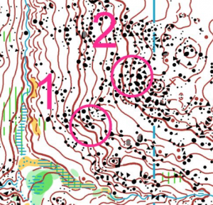
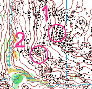
Consider the leg between these two controls on a steep hillside
⇐ Leg 1 to 2 is uphill and competitors will
be moving slowly = EASY (well, easier)
Leg 1 to 2 is downhill and competitors
will be moving quickly = HARD ⇒
The direction your course approaches control sites can dramatically change its character and technical difficulty
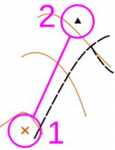
⇐ Consider this leg 1 to 2
Now imagine the map was wrong and the boulder
is actually as shown on the right ⇒
The attitude “it’s the same for everyone” is unfair – a competitor going straight (dotted line) will see the control while a runner taking the track option will not
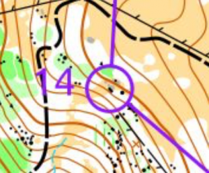
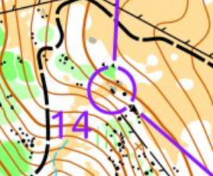
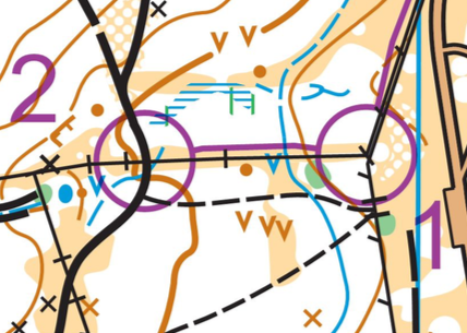
⇐ The number “1” in “14” is obscured by the track, the circle and lines obscure features on the map
Position the number carefully and cut lines and
circles so that no important details are obscured ⇒
Don’t obscure important details
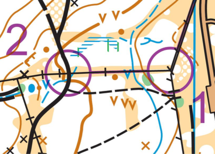
⇐ The lines between the controls are obscured
Position the lines (use “bends” or similar if required)
such that no important details are obscured –
particularly on a beginners (Very Easy or Easy) course ⇒
Don’t obscure important details
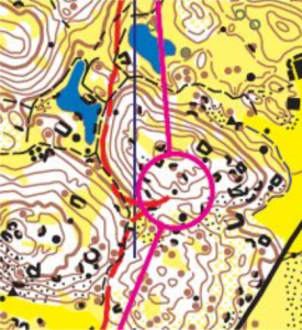
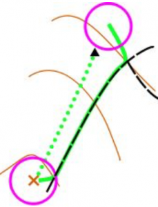
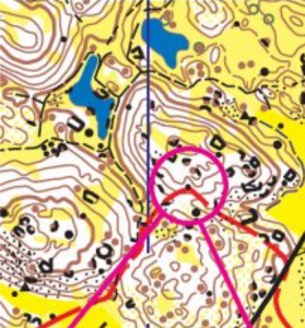
⇐ On paper this leg does not look like a dog leg but when considering route choices it is actually a dog leg
On paper this looks like a dog leg but looking
at the route in and out of the control it is
clear that it is not a dog leg ⇒
While a course should “look good” on paper (smooth without acute angles), the way your course flows is dependent upon the route runners will take
through the terrain
Terminology
| Course Planner | The person responsible for setting/planning the course. Often referred to as a course setter. |
| Controller | An official role who is responsible for the running of the event. The controller will review the courses and do field checking of control sites (with or without the course planner). |
| Vetter | For events that don’t require an official controller, the vetter will review the courses and do field field checking of control sites (with or without the course planner). |
| Event Organiser | The event organiser co-ordinates the organisation of the event. They are responsible for collection of equipment (tents, tables, etc), assigning volunteers to particular jobs, and assuring the smooth running of the event. |
| Sprint | Short, fast paced races, usually in technical terrain with lots of loops, changes of direction, short control legs, and route choice. Official Definition: “The Sprint profile is high speed. It tests the athlete’s ability to read and translate the map in complex environments, and to plan and carry out route choices running at high speed. The course must be planned so that the element of speed is maintained throughout the race. The course may require climbing but steepness forcing the competitors to walk should be avoided. Finding the controls should not be the challenge: rather the ability to choose and complete the best route to them. For example, the most obvious way out from a control should not necessarily be the most favourable one. The course should be set to require the athletes’ full concentration throughout the race. An environment which cannot provide this challenge is not appropriate for the Sprint.” |
| Middle Distance | The “normal” courses people are used to! Winning times of 30-35 minutes. Standard line courses. Official definition: “The Middle distance profile is technical. It takes place in a non-urban (mostly forested) environment with an emphasis on detailed navigation and where finding the controls constitutes a challenge. It requires constant concentration on map reading with occasional shifts in running direction out from controls. The element of route choice is essential but should not be at the expense of technically demanding orienteering. The route in itself shall involve demanding navigation. The course shall require speed-shifts, e.g. with legs through different types of vegetation.” |
| Long Distance | Long distance Orienteering. Winning times about 50-60 minutes and feature one or more long legs with route choice. Official definition: “The Long distance profile is physical endurance. It takes place in a non-urban (mostly forested) environment, and aims at testing the athlete’s ability to make efficient route choices, to read and interpret the map and plan the race for endurance during a long and physically demanding exercise. The format emphasises route choices and navigation in rough, demanding terrain, preferably hilly. The control is the end-point of a long leg with demanding route choice, and is not necessarily in itself difficult to find. The Long distance may in parts include elements characteristic of the Middle distance, with the course suddenly breaking the pattern of route choice orienteering to introduce a section with more technically demanding legs.” |
| Winning Time | This is the time for the fastest person running the course. There will be many people that will take much longer than this (up to three or even four times as long). You should assume the winning person will make very minimal mistakes and run as fast as the terrain allows. |
