Newcomers are always welcome. If you have any questions look for the “Newcomers” flag or the “Ask Me” person at any event and we’ll help you get started!
What is orienteering?
Orienteering is a navigation sport where you visit checkpoints using a map. You decide on your own route to get around the course, as long as you visit each checkpoint in order.
Should you take the track and go the long way round, or go straight through the bush? Do you take the shorter, but hillier way, or take a track the long way round? These are the decisions that each person makes during their course.
Orienteers use only map and compass to navigate. A compass is not needed to get started. In fact, the main skill in orienteering is reading the map and relating it to the terrain, and you can do that with just your eyeballs and brain.
Orienteering is a sport where beginners and elites can be active side by side, and all ages are represented. You are never too old or too young for orienteering!
How does it work?
Find an Event
The ACT holds about 100 events every year. All include courses suitable for beginners and there are always people willing to help you get started. Visit the Events page for details, and use the navigation links for driving directions. For an overview of the types of events Orienteering ACT hold, see Event Series Overview.
Orienteering is really flexible. You can start any time of the year, and you don’t have to come regularly. You just pay on the day. And every event has a starting window, so you chose when to start.
When You Arrive
-
Ask a person wearing a high-vis “Ask Me” vest for a quick tutorial on what to expect and how to read the map.
-
You will need to choose which course to do:
-
Very Easy – very easy navigation and usually around 1.5km
-
Easy – easy navigation and usually around 3km
-
Moderate – medium navigation. There are usually multiple moderate courses ranging from 3km to 6km
-
Hard – hard navigation. Courses could range from 3km to 15km
-
-
Check-in at the registration tent. Pay your entry, pick up an SI stick (electronic timing device), a map (and hire a compass if you want one).
-
You must also register your SI at the computer (usually at the opposite end of the tent). This is important so we know you are out on the course.
The event will have a start window, for example 10:30am – 12:00pm, and you can start any time between those times. There will also be a course closure time, for example 2:00pm. You need to be back before course closure or a search party may be sent out looking for you.
Go to the Start
You then need to make your way to the start. The start is often close by and will have a large Start banner flag waving in the breeze. If the start is a short walk away there will often be signs or you might have to navigate there yourself. The start is marked on the map as a purple triangle.
At the Start
The first thing you need to do is clear your SI Stick. Insert it in the box called “CLEAR” until it beeps and flashes. After that works, insert it in the “CHECK” box. It should beep and flash. If not, try clearing again. When you are ready, insert into the “START” box and you’re ready to set off!
Some Terminology
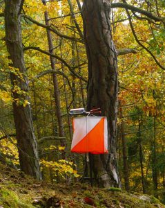
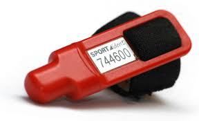
SI Stick = E Stick = E Punch = Dibber = Electronic timing device that straps to your finger Punch = verb. to insert your SI Stick in a control (electronic box) Control = Checkpoint = the points on the map that you need to visit (in order). Controls have a orange and white flag and an SI Unit (the electronic box that you put your SI Stick into)
Navigating the Course
The purple triangle is the start, then each control is numbered sequentially and connected with lines, ending in the finish, which is the two concentric circles. Follow this basic set of instructions for each control:
-
Find where you are on the map
-
Orient the map so that it matches the terrain (or use a compass)
-
Figure out how you’ll get from your current position to the next control
-
Set off and track your position using your thumb or the tip of a compass on the map
Visit the Skills page to learn basic navigation skills
Finding a Control
 Navigate your way to the centre of a circle. Look for a bright orange and white flag with a numbered electronic box on top.
So you should punch it, right? But wait! If there are multiple courses, you need to make sure that this control is on your course and not another.
There is a grid printed on the map that tells you codes and descriptions of the controls you are looking for. The first control might be number 31, with a description of “Track Bend”, the second control might be 102 with a description of “Termite mound, East side” and so on. You need to make sure that the control you found is the correct one by checking the number. If it’s the wrong number, then you need to figure out where you’ve ended up and navigate to the correct spot.
Punch!

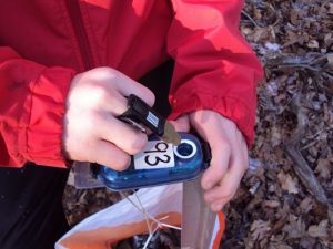
If the number of the control is correct, then punch the control (insert your SI Stick in the box attached to the flag). The box will beep and flash as confirmation. In the rare case that the box does not beep or flash, use the red pinhole-punch dangling from the flag to manually punch your map.
Note: it’s okay if you accidentally punch the wrong control, so long as you eventually punch all the correct controls in the correct order.
Finishing
When you’ve found all the controls on your course, head to the finish, which is marked as two concentric circles on the map. Similar to the start, there will be a Finish Banner Flag and a Finish Control box. Once you punch the finish, your time is recorded.
Download
After you finish, go to the registration tent to download the data from your SI Stick. If you’ve rented an SI, you return it here.
Once you’ve downloaded, you’ll get a receipt that shows your split times, which is the amount of time you took between each control. Part of the fun of orienteering is comparing your splits with friends, and discussing the routes you took between each.
Even if you have not finished your course, you MUST return to download, so that event staff can confirm that you are not still out on the course. If you do not download, a search party may be sent to look for you.
You Did It!
That’s it, you did it!
How much do I need to know?
You don’t need to know a thing!
That’s right. All events include a beginner and intermediate course, or are otherwise adjustable to your ability. Plus, at every event there will be people who can help you get started. Look for the person wearing the high-vis “Ask Me” vest or ask at the registration desk.
If you can find the lions by reading a zoo map, then you can orienteer.
What's an SI Stick?

An SI Stick, short for SPORTIdent after the company that makes them, records your start time, which controls you visit (including how long it took to get there), and your finish time.
At each control, insert the SI Stick into the electronic box, which will beep and flash as confirmation. After you finish, you’ll download the SI Stick at the registration tent and get a receipt that show which controls you visited and how long you took between each; these are your “splits.”
Part of the fun of orienteering is comparing your splits with people who completed the same course, and discussing the routes you took!
An SI Stick is the only piece of essential equipment for orienteering. You can hire an SI for every event, but it’s recommended that you purchase one (once you’re hooked of course!) as it makes administration and entering events easier for you and the organisers. Orienteering ACT sells SIs, as do other suppliers. For a list see here: Equipment Suppliers.
Do I have to run?
How long will the course take me?
Courses are measured as the crow flies, meaning directly from one control to another. However, since you are not a crow, you will travel farther than this distance as you zig-zag to get to each checkpoint. You could roughly add 20% or 30% to the distance for how far you will actually go.
There are a few things that slow you down compared to running or walking on a footpath. Firstly, the terrain will be slower. You’ll be going through bush, on dirt tracks and maybe climbing over rocks or fallen timber. Secondly you can only go as fast as you can navigate. You’ll get better with experience, but if you brain can’t keep up with your feet you’ll find you aren’t quite sure where you are and waste a lot of time re-locating!
Most courses take about 30-90 minutes.
What course do I choose?
VERY EASY courses stay on tracks, have very easy navigation and are good for children accompanied by adults.
EASY courses take short excursions off-track, have easy navigation and are appropriate for new teens and adults.
MODERATE courses have most routes off-track, have moderate navigation, and may require reading subtle map details.
HARD courses are completely off track, hard navigation and require a lot of experience and skill.
There are often several Moderate and Hard courses on offer of different lengths. Be conservative when you are trying an Moderate or Hard course for the first time as the navigational challenge means that the course will probably take you longer than you anticipate.
What should I wear?
Dress for your speed. If you plan to walk, quick-drying hiking pants and day hiking shoes are a good choice. If you plan to run, running tights, tall socks, and trail running shoes will suit you better.
It’s often a good idea to cover your legs. Especially at bush events you may find yourself pushing though long grass or undergrowth. For the very urban parks like Weston Park and Commonwealth Park you can wear shorts and T-Shirt.
What equipment do I need?
SI stick – you can hire this at the event, or buy one when you’re ready.
Compass – not required initially, but you can hire them at the event. Please note that you need to be careful purchasing compasses on the Internet as the compass must be properly weighted for the southern hemisphere to work correctly.
Whistle – It is recommended that a whistle be carried for emergency use, particularly in bushland events. On some events in remote areas, carrying a whistle may be compulsory.
Control Description Holder – optional. This straps to your arm and holds a separate printed control description. The control descriptions are also printed on the map, but many orienteers fold their map so having a separate list is more convenient, especially when running at speed.
We encourage beginners to carry a mobile phone with you.
To purchase Orienteering equipment, see Equipment Suppliers
Can I do it in a group or a team?
Yes! You may participate in a group as large as 6 people, though for the best experience, we recommend that your group be only 2 or 3 people, so everyone stays engaged in the activity.
Also, we recommend that everyone in your group carry a map.
Can I bring my dog?
Orienteering ACT has a policy that no dogs are allowed at events. The exception to this is the Street Series of events.
Can I follow other people?
Most orienteering events are designed to discourage following. If you see another orienteer, they may be on a different course, at a different point on your course, or they could even be making a navigational mistake! It’s better to focus on your own race, and don’t follow others.
What do I do if I get lost?
If you don’t know where you are on the map:
Stop!
Look around you, and look at the features you see in the terrain. It’s okay to move around or seek higher ground to see more features. Note what direction the features are facing as well.
Try again to find those features on the map, in the orientation that you see them.
If you’re still confused, then either:
Go to a larger, more prominent feature and try again.
Or, backtrack to where you last knew you were.
Finding larger features and backtracking are usually enough to relocate yourself, but if you are still very confused, it is okay to ask for help if you encounter a non-competitive orienteer. You are more likely to encounter an orienteer by waiting near a control.
If you are still very confused and don’t see anyone around, you should do one of the following, depending on your situation:
Head toward a large feature like a road to head back to the finish, if you are confident in your ability to do so. Many venues, even very rugged ones, have large features like roads that can help you navigate back to the finish. In difficult terrain the map will usually have a Safety Bearing printed on it, eg. “South to the Highway”.
If you cannot navigate back to the finish, due to being absolutely lost or injured, then blow your whistle using six short blasts, and repeat until someone finds you. Note that orienteers are obligated to abandon their course and attend to the call of a whistle, so only blow your whistle if you are truly lost or hurt and cannot make it back to the finish.
